| |
 |
SSSI - professional spatial sampling and statistical inference tool.
SSSI is the most comprehensive, scalable spatial sampling software, supports for spatial data storage, display and analysis. It provides a variety of sampling models for different geographical survey. Each model has functions to calculate sample size, lay out the sample sites and display the results of sample statistical inference.
As a distinguished and highly efficient sampling software, SSSI with the basic functions of GIS has powerful sampling features, data collection and statistical analysis in one package. Through easy-to-use interface design and high efficient sampling functions, allows users to complete simple or complex sample design in a number of ways. The prominent features of this software is interface-friendly, visual and clear output.
Facilitated by the modular infrastructure design of the software, the product will continue to embed the state of the art of advanced theories and technologies related with spatial sampling. A higher version of this software is also brewing, will be adding more functions, user-friendly.
The software available for research, teaching, public service, non-profit use. It is prohibited for commercial purposes without permission.
In today's society, it is necessary to carry out environmental monitoring, economic surveys, health survey, commodity inspection and a series of investigations. These survey objects are relative large, it is impossible to inspect all the objects one by one as it will cost a lot of human, material and financial resources and time. Instead, we can estimate the overall population by sampling techniques. Sample survey has become a scientific method and an important means to access information. At present, there are some of sampling softwares with a simple function, but none of them are dedicated to deal with spatial sampling problem. Due to spatial correlation, heterogeneous, non-repetitive, the classic theory and methods of random sampling can not deal with spatial distributed objects properly. When the classical sampling technique was applied to spatial sampling, it worked at low efficiency, and even bias (Cochran, WG. (1977). Sampling Techniques, 3rd ed. USA: John Wiley & Sons; Haining, RP (2003). Spatial Data Analysis: Theory and Practice. Cambridge: Cambridge University Press). This software is making up for gaps in this field. The software uses module design, based on VC + + core algorithm, provides a highly efficient processing capability. Through the use of the GIS library SuperMap it achieved on the graphical display, query, storage and other basic GIS functions.
The overall structure of SSSI is designed based on spatial optimization sampling strategy of Trinity theory (Wang JF, Haining R, Cao Z D. 2009. Spatial Sampling for Estimating the Mean of a First Order Heterogeneous Surface. In press). The high efficient "sandwich spatial sample model" comes from Wang JF, Liu JY, Zhuang DF, Li LF & Ge Y. 2002. Spatial sampling design for monitoring the area of cultivated land. International Journal of Remote Sensing, 13, 263 -- 284.
Sampling survey is a kind of scientific method and an important means to obtain information, it is applied to a wide range in environmental, social, economic, scientific and other fields, and also in government departments, social organizations, enterprises. The software can also used in land resources survey, ecological survey and satellite monitoring, monitoring the traffic flow in a city. For example, on the planned monitoring network to calculate the optimum distribution and density to form a highly efficient spatial sampling project or monitoring network.
To evaluate current monitoring network, recommend the best overall valuation methods and recommendations to improve the monitoring network.
Through the study of estimate sample distribution and density, the SSSI can be used to to evaluate the accuracy and reliability of statistic figures.
1. Data input and output
Reading and Writing Project file
Import map of the region of interesting
Import stratified file
Save project files
To create and preserve a sample site file
2. Sampling region and parameter settings
Select a sample region
Select a sample model (simple random sampling, systematic sampling, stratified sampling, spatial
random sampling, spatial stratified sampling, and sandwich sampling)
Import sample size calculation function and required parameters 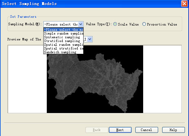  3. Spatial stratification
Expert experience stratification
K-means stratification 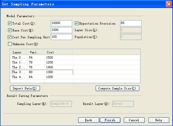 4. Visualization and query
Show up spatial layout of sample sites
Show up sample sites’ attribute table and attribute query Show up the dynamic link between sample sites layout and attribute table  5. Spatial Analysis and Statistics
Select statistical inference models
Set parameters
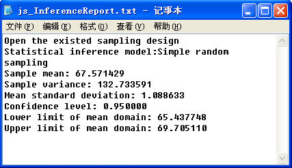
Show up the sampling results: sample site table and scatter map 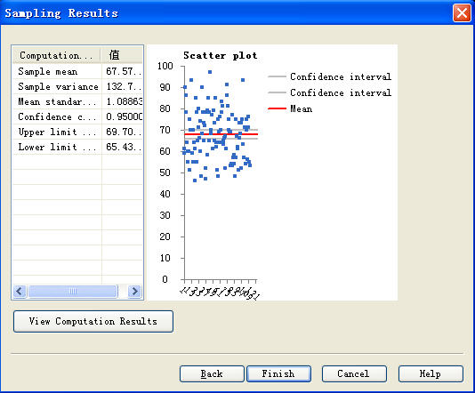 6. A sampling designreport and statistical inference report produced by the software
After the end of the first sampling stage, the software automatically generated the sampling result report as follows: 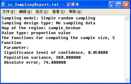 The third stage of a sample statistical inference report as follows:
1) friendly interface, humane
Flexible simple operation software, easy to learn and use; the results of statistical inference can be represented by charts, clear and visual.
2) High sampling efficiency
"sandwich sampling model” in the Software has a higher sampling efficiency. On the basis of spatial stratified sampling, a reporting units layer is added, which is the final report unit that user would like to use, for example, the county border, provincial boundaries, basin, the artificial grid and so on
3) powerful sampling based statistical inference tools
SSSI is designed based on spatial optimization sampling strategy of the Trinity theory (a theory about the relationship between surface-sampling-statistic). It can be used separately or combined in spatial sampling design, spatial statistical inference and valuation of accuracy.
4) Modular software
The entire Sampling process from input-output perspective can be divided into three modules: input module, processing module, output module. The processing module is further composed of extendable modules to embed sampling models. The modular software design is easy to manage, with good scalability.
5) Provide the basic GIS functions
Provide graphics, data management, graphics browser Zoom basic GIS functions. Generate a sample sites’ distribution map. The map display for spatial analysis and statistics.
6) Support a variety of data formats
The software can read a variety of file formats, not only to support vector and grid format, into map of the region of interesting, also supports the picture. jpg, .tif format, which greatly facilitate users
7) Intelligent
In the calculation of sample size, as long as users understand the basic sampling principles without the detail knowledge of the various models, users can get required sampling results through simple operations. The software can automatically draw graph of relationship between accuracy, cost and sample size.
when the sample ratio is greater than 15%, the system will automatically call to adjust the formula. In the sampling process a variety of optiosn could be chosen through the "dialog" to complete the operation, users don’t need to remember options and parameters.
Principal Investigator: Jin-Feng Wang
Software Design: Jin-Feng Wang
Theoretical R & D: Jin-Feng Wang, Robert Haining, Cheng-Sheng Jiang, Mao-Gui Hu, Zhi-Dong Cao, Lian-Fa ,
Yong Ge (add in)
Project Management: Cheng-Sheng Jiang
Software Development: Cheng-Sheng Jiang, Mao-Gui Hu, Xin-Li JiangSupermap R & D center
Software Testing: Cheng-Sheng Jiang, Mao-Gui Hu, Ai-Hua Ma, Supermap R & D center
Compilation menu: Cheng-Sheng Jiang, Ai-Hua Ma, Yan-sha Guo, Supermap R & D Center, Jin-Feng Wang
(validated)
Release Management: Cheng-Sheng Jiang, Yan-Sha Guo, Ai-Hua Ma, Supermap R & D center
English translation: Mike Ning ( Canada), Yan-Sha Guo
GIS Technology: Supermap R & D center
Flat packaging: Chinese National Geographic magazine
Demo from:
1, Health Survey: Chinese Academy of Sciences geographical resources. Zhi-Dong Cao, Mao-Gui Hu
2, The area under cultivation of agricultural monitoring: the Ministry of Agriculture Zhou Qingbo
3, Crop monitoring: Remote Sensing, Chinese Academy of Sciences by Wu Bing Fang, Li Qiangzi
4, Census:, Chinese Academy of Sciences geography resources by Wang Yingjie
5, soil survey:
6, land-use survey:
 | Jinfeng Wang, born on March 24, 1965, PhD, Professor. State Key Laboratory of Resources & Environmental Information System, Institute of Geographical Science and Natural Resources Research, Chinese Academy of Sciences, Chair Professor; International Geographic Union: Commission on Modeling Geographical System, Chinese Association of Geographic Information System, Commission of Theory & Methodology; Editorial board member of 《Geographical Analysis》,《Journal of Geographical Systems》,《Stochastic Environmental Research and Risk Assessment》and《Journal of Geographical Science》and so on. Had studied at more than ten foreign institutions such as Cambridge University, National Centre for Epidemiology & Population Health of Australia. Research ranges from spatial data analysis, GIS modeling to spatial operation research. Had held and participated in “NSFC Program”,“863” Plan, “973”Plan, National Key Technologies R&D Program of China and International Cooperation Programs and published 9 books, 200 thesis, among them 40 is SCI papers. In spatial sampling theory, Jinfeng Wang and his members put forward "Spatial sandwich sampling model with high efficiency" and "spatial optimal sampling strategy--triunity theory";Presided, designed and developed "Sandwich spatial sampling and inference (SSSI)" . Gained 2 software registrations and 3 patented inventions.
Email: wangjf@Lreis.ac.cn or wangjf@igsnrr.ac.cn |  | Chengsheng Jiang,Institute of Geographical Science and Natural Resources Research, Chinese Academy of Sciences, PhD,
Research direction: spatial sampling analysis and statistical inference theory, and so on. |  | Maogui Hu,Institute of Geographical Science and Natural Resources Research, Chinese Academy of Sciences, Ph.D. Research direction: superresolution remote sensing image and spatial analysis. |  | Zhidong Cao, Institute of Geographical Science and Natural Resources Research, Chinese Academy of Sciences, Ph.D. ,
Institute of automation chinese academy of sciences, post-doctorate. Research direction: ction:spatial sampling, spatial epidemiology. |  | Yong Ge, PhD, Institute of Geographical Science and Natural Resources Research, Chinese Academy of Sciences, associate professor, Research direction: spatial data processing and information access, uncertainty analysis and quality evaluation |  | Lianfa Li, Institute of Geographical Science and Natural Resources Research, Chinese Academy of Sciences, assistant professor, Reseach direction: spatial sampling, spatial data analysis and data mining, risk analysis and assistant decision support system system. |  | Aihua Ma, Beijing Normal University, School of Geography and Remote Sensing. Research direction: soil sampling and statistical inference, SSSI software and case. |  | Yansha Guo, Institute of Geographical Science and Natural Resources Research, Chinese Academy of Sciences, Ph.D. Research interests: virtual reality, parallel computing ,spatial analysis |  | Xinli Jiang,China university of petroleum(East China), College of Computer and Communication Engineering, Master, Institute of Geographical Science and Natural Resources Research, Chinese Academy of Sciences,guest master. Research direction: 3D vector field visualization |
|
|
|
|
|