Welcome to Sandwich Website
Sandwich Spatial Estimation
Introduction
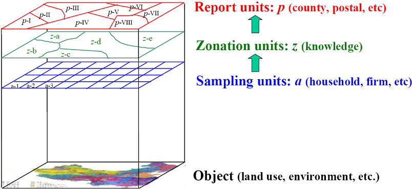
Sandwich spatial estimation is a technique to
interpolate areal values for a stratified domain.
- Output: the means and their
variances of multi report units;
- Input: a sample and a
zonation layer.

Fig.1 The framework of "Sandwich estimation" theory software.
How to use this software
1. Data preparation
All data should be in ARCGIS format.
Click “Add Layer” button![]() , an “Add
Layer” dialog display as shown in Fig.2. Select a shp
file, a shp layer will be added in current map.
, an “Add
Layer” dialog display as shown in Fig.2. Select a shp
file, a shp layer will be added in current map.


Fig.2 Add Data dialog.
2. Parameters setting
Click “Sandwich Infer” button, a “Sample Infer” dialog displayed as shown in Fig.3

Fig.3 Sample Infer dialog.
Firstly, user selects a report layer (Report Layer) and its key field (Report Key Field), which could be ID or name.
Secondly, select a zonation layer (Zonation Layer) and its key field (Zonation Key Field), which could be ID.
Thirdly, select a sample layer (Sample Layer) and its key field of ID (Sample Key Field) and the item of sample value (Sample Value Field).
Finally, select the population layer to calculate the weight of each zone unit in a reporting unit (Population Layer).
3. Results
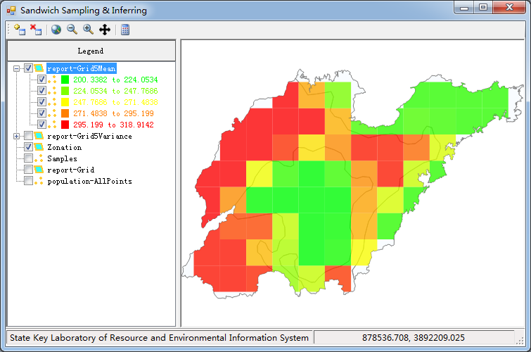
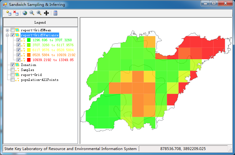
Click the “Calculate” button in Fig.3, two windows appear: one is text report, the other is thematic map of estimated mean and variance, as shown in Fig.4.


Fig.4 Sandwich results
Case Study
Two sample datasets: one is Hing’an area case, and the other is Shandong province case. The parameter settings of Shandong case are displayed in Fig.3. The parameter settings of Hing'an case are displayed in Fig. 5.

Fig.5 Parameter settings for Shandong case
Download and Installation
The Sandwich software runs in Windows 7 or up with Microsoft
.Net Framework 4.0 installed. It is completely free.
You can practice the two cases in our Sandwich paper:
Citation: Wang JF, Haining R, Liu TJ, Li LF, Jiang CS. 2013. Sandwich spatial estimation for multi-unit reporting on a stratified heterogeneous surface. Environment and Planning A, 45, 2515–2534. Download
References:
1. Wang JF, Liu JY, Zhuang DF, Li LF
& Ge Y. 2002. Spatial sampling design for monitoring the area of cultivated land.
International Journal of Remote Sensing, 13, 263-284.
Download
2. Wang JF, Jiang CS, Li LF, Hu MG. 2009. Spatial Sampling and Statistical Inference (in
Chinese). Beijing: Science Press. Browse
3. Wang JF, Haining R, Cao ZD. 2010. Sample surveying to estimate the mean of a heterogeneous surface: reducing the error variance through zoning.
International Journal of Geographical Information Science, 24, 523-543.
Download
Contact: liutj@Lreis.ac.cn (Tiejun Liu) or wangjf@Lreis.ac.cn (Jinfeng Wang)
Address: Room 2305, A11 Datun Road, Beijing, China.
| Visitors to Sandwich: | Previous visitor totals: | |
 |
Copyright: 201 Spatial Analysis Group, IGSNRR, CAS. Last updated: 12/31/2013.